Digital Orthophotography
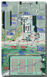 Our in-house mapping specialists provide digital orthophotography to correct image displacements in aerial photographs and render an image that can be viewed at a consistent scale.
Individual aerial photographs or perspective photographs taken from a single point, do not exist at a single scale. They show the displacement of the image elements caused by the effects of terrain relief and the orientation of the camera at the time of exposure. An aerial photo by itself can not easily be used to make accurate measurements.
Digital orthophotography, along with topographic mapping files viewed in a CAD or GIS software environment, combine the benefits of mapping elements in vector (CAD) form and the map characteristics of the orthophoto at a consistent scale.
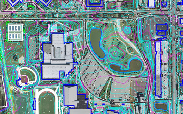
High resolution orthophoto imagery delivered in a variety of horizontally accurate and scalable file formats provide flexible data solutions you can integrate into your project work flow.